Statistically-based methodology for large scale landslide susceptibility modelling of small and shallow landslides in the Pannonian Basin
Author: PhD Marko Sinčić, MScEng.
About 30% of Croatia’s territory is at risk of landslides. These natural events can cause serious damage to homes, roads, and other infrastructure, as well as threaten people’s lives. Because of this, understanding where and why landslides happen is essential for protecting communities and reducing disaster risks. One of the most important tools in preventing landslide damage is the creation of landslide hazard maps. These maps help experts predict where, when, and how big a landslide might be. To make such maps, scientists first need to understand landslide susceptibility—in other words, how likely it is that a landslide could occur in a certain area (Guzzetti et al., 1999).
The doctoral research described in this blog focused on developing a methodology for mapping landslide susceptibility in large scale following the defined steps for landslide susceptibility assessments (Reichenbach et al., 2018). The work specifically targeted small and shallow landslides, which are very common in the Pannonian Basin—a large lowland area that stretches across parts of Croatia and neighboring countries. The research used statistical and machine learning methods to better understand the relationship between environmental conditions and landslide occurrence. The research followed a designed framework made up of five key steps to define a methodology:
Analyzing data quality – checking how accurate and complete the available landslide data was.
Testing classification methods – experimenting how to best categorize different environmental factors that influence landslides.
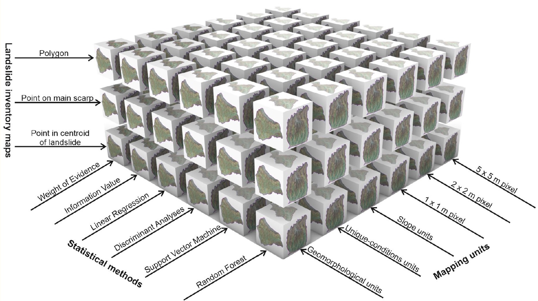
Exploring sampling strategies – deciding how to collect and organize data from both stable (no landslide) and unstable (landslide) areas (Figure 1).
Comparing statistical methods – evaluating different types of models to see which predict landslides most effectively.
Evaluating the results – using various accuracy measures to test how reliable the models were.
The framework was applied to three study areas in Croatia that represent typical geological and environmental conditions of the Pannonian Basin, namely: 20 km² area in Hrvatsko Zagorje, a smaller 21 km² part of the Podsljeme area and the entire Podsljeme area, covering about 130 km². (Figure 2).
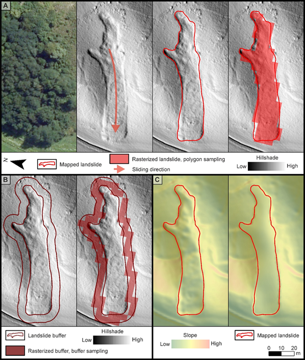
Figure 1 Examples of sampling strategies:(A) polygon sampling,(B) buffer sampling and (C) smoothed landslide conditioning factor sampling. (Sinčić et al., 2024)

Figure 2 Geographic positions of study areas; in Europe (A), in Croatia (B), in NW Croatia (C). Detailed presentation of the study areas: whole Podsljeme Area in the City of Zagreb (D), selected representative Podsljeme Area (E) and selected representative part of Hrvatsko Zagorje (F) (Sinčić, 2025)
The first major finding was that data quality is absolutely crucial. To create reliable maps, it’s important to have an accurate landslide inventory (a detailed record of past landslides) and high-quality information about the conditions that cause them, such as soil and rock type, terrain characteristics, and vegetation. This can be achieved mainly through remote sensing technologies (Figure 3), especially LiDAR (Light Detection and Ranging) and high-resolution orthophoto imagery, which allow scientists to detect even small changes in the landscape (Sinčić et al., 2022).

Figure 3 An example of how high-resolution digital terrain model (DTM) (acquired by LiDAR) derivatives enable improving the spatial accuracy of geological landslide conditioning factors (Sinčić et al., 2022)
The research also compared several modelling approaches. Machine learning techniques, like neural networks and random forests, showed the best predictive performance. However, they were also more sensitive to small changes in how the models were set up. On the other hand, more traditional methods—like logistic regression and information value analysis—were found to be more stable and easier to control, while still performing well.
Another key insight was about sampling and data classification. When selecting stable areas for comparison, using randomly chosen points worked best. (Sinčić et al., 2024) Additionally, it was found that the accuracy of models improved when environmental factors were divided into more than ten categories—or, even better, when they were used as continuous data without being divided into categories at all (Sinčić et al., 2025).
The study also tested how these models could be applied in large scale mapping. In the larger 130 km² Podsljeme area, it was demonstrated that using results from a smaller but geologically similar test area (the 21 km² Podsljeme area) made the process faster and more cost-effective. This approach could be very useful for large regional mapping projects (Bernat Gazibara et al., 2023).
Finally, the research emphasized the importance of not only quantitative (numerical) assessments (Figure 4) but also qualitative evaluations (Figure 5) —expert judgments based on real-world knowledge of the terrain. Combining both methods led to more reliable and meaningful results.

Figure 4 An example of quantitative model assessment, namely Cohen's Kappa and Area Under the Curve (AUC) values (Sinčić et al., 2024)

Figure 5 An example of qualitative model assessment, namely close up view comparisons of classified landslide susceptibility models (Sinčić et al., 2024)
Overall, the doctoral study provided a clear and practical methodology for assessing landslide susceptibility at a large scale. The framework outlines essential steps—from gathering and checking data to applying the most suitable models—and highlights the importance of using accurate input data like landslide inventories and conditioning factors. The findings can support better land use planning, risk reduction, and mitigation strategies.
Reference
Bernat Gazibara, S., Sinčić, M., Krkač, M., Lukačić, H., Mihalić Arbanas, S. (2023): Landslide susceptibility assessment on a large scale in the Podsljeme area, City of Zagreb (Croatia). Journal of Maps, 19, 1.
Guzzetti, F., Galli, M., Reichenbach P., Ardizzone, F., Cardinali, M. (1999): Landslide Hazard assessment in the Collazzone area, Umbria, Central Italy. Natural hazards and earth system sciences, 6, 1, 115-131.
Reichenbach, P., Rossi, M., Malamud, B.D., Mihir, M., Guzzetti, F. (2018): A review of statistically-based landslide susceptibility models. Earth-Science Reviews, 180, 60-91.
Sinčić, M., Bernat Gazibara, S., Krkač, M., Lukačić, H. & Mihalić Arbanas, S. (2022) The Use of High-Resolution Remote Sensing Data in Preparation of Input Data for Large-Scale Landslide Hazard Assessments. Land, 11, 1360.
Sinčić, M., Bernat Gazibara, S., Rossi, M., Krkač, M., Mihalić Arbanas, S. (2024): A Comprehensive Comparison of Stable and Unstable Area Sampling Strategies in Large-Scale Landslide Susceptibility Models Using Machine Learning Methods. Remote Sensing, 16, 16, 2923.
Sinčić, M. (2025.): Statistically-based methodology for large scale landslide susceptibility modelling of small and shallow landslides in the Pannonian Basin 2025., doctoral dissertation, Faculty of Mining, Geology and Petroleum Engineering, Zagreb, 174 p.
Sinčić, M., Bernat Gazibara, S., Rossi, M., Mihalić Arbanas, S. (2025): Comparison of conditioning factor classification criteria in large-scale statistically based landslide susceptibility models. Natural Hazards and Earth System Sciences, 25, 183-206.
PhD Marko Sinčić, MScEng. is a Postdoctoral researcher at the Department of Petroleum and Gas Engineering and Energy on the Faculty of Mining, Geology and Petroleum Engineering, University of Zagreb. He finished his PhD on 23.4.2025. with a dissertation entitled Statistically-based methodology for large scale landslide susceptibility modelling of small and shallow landslides in the Pannonian Basin.
E-portfolio Link
ResearchGate Link
Google Scholar Link
CROSBI Link
Project website Link